Lingnan University develops real-time GeoAI Platform for mosquito-borne disease control

Mosquitoes transmit diseases easily, and some are fatal. In view of this, the Science Unit of Lingnan University has developed a Geospatial artificial intelligence (GeoAI) system, which combines GeoAI technology, an internet of things platform, and geographic information to generate a Mosquito Risk Index and a Mosquito Risk Map for the general public with real-time information about mosquito infestations on a regional basis, and assist Hong Kong in predicting mosquito infestations and controlling mosquito-borne diseases with the use of big data analysis.
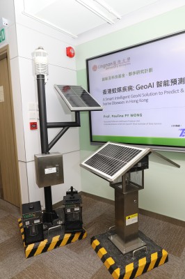
The GeoAI Cloud Analytics Platform, an GeoAI system developed by Lingnan University, generates the Mosquito Risk Index and Mosquito Risk Map by analysing the mosquito population and meteorological data provided by Lingnan University’s Intelligent Mosquito Killer Lamps system, which has been installed in 16 districts in Hong Kong, coupled with environmental data such as the location of the vegetation and water sources in the area, etc., as well as the mosquito trap indices from the Food and Environmental Hygiene Department of the HKSAR Government.
Members of the public can visit Lingnan University’s Mosquito Risk Platform to obtain the real-time and predicted mosquito situations in various districts, and avoid going to areas with serious mosquito problems.
This government-industry-academia-research collaboration project led by Prof Paulina Wong Pui-yun, Head of the Science Unit of Lingnan University has received a total funding of HK$3.3 million from the Innovation and Technology Fund (ITF) Partnership Research Programme of the HKSAR Government and its partner in the project, Triple Faith Engineering & Supply Limited. The project will last for about 18 months.